Planetary Prediction Engine: Autonomous Geospatial Modeling via LLM-Orchestrated Stages
Google Research presents the Planetary Prediction Engine (PPE), an experimental autonomous system that executes geospatial prediction workflows from natural-language queries, spanning data discovery, curation, model training, and reporting. Reported evaluations show consistent gains over manual pipelines across health, disaster risk, food insecurity, and outbreak nowcasting, most notably doubling Nigeria ADM2 food-security downscaling R² and a 10.3-point Recall@10 improvement for DRC Ebola hotspot nowcasting. The core constraint shift is replacing weeks of manual geospatial data engineering with minutes of autonomous insight, enabled by opaque data handles that avoid LLM context-window limits. Evidence is self-reported and lacks independent replication.
The Planetary Prediction Engine is new in scope rather than in any single component: it wraps AutoML, LLM orchestration, and geospatial data discovery into one autonomous pipeline whose intermediate artifacts are passed as opaque handles, not text. This architectural choice specifically addresses the context-window bottleneck that has limited previous LLM-based agents to pre-curated tabular data. The substantive claim is that a single system can match or beat specialized manual pipelines across public health, food security, environmental risk, and socioeconomic prediction without human data engineering.1
Context
PPE decomposes prediction into three stages—intelligent data selection, dataset curation, and AutoML & prediction—each orchestrated by off-the-shelf LLMs with well-defined inputs and outputs. Evaluations include 21 CDC health indicators (mean R² 76.8% vs 60.0% manual baseline), FEMA national risk indicators (64.9% vs 60.0%), Social Vulnerability Index (66.2% vs 58.6%), Nigeria food-security downscaling from ADM1 to ADM2 (66.1% vs 31.5%), and DRC Ebola new hotspot nowcasting (Recall@10 83.3% vs ~73% published Bayesian baseline). The authors attribute gains to multimodal fusion of statistical covariates with latent foundation-model embeddings.1
Assessment
The evidence is suggestive but methodologically thin. All metrics are self-reported on unknown benchmark construction; the manual-expert baseline is not specified in terms of team composition, allowed time, or validation protocol. The Ebola comparison cites a 'published' baseline without a citation, and the reported +10.3 percentage point improvement is not accompanied by uncertainty intervals. Across five sequential weekly forecasts, 15 of 18 true positives in a top-10 list is a small sample, and the operational meaning of recall depends on the number of candidate zones per forecast.1
Caveats
AI hypothesisThe strongest test of PPE would be independent replication on a fixed public benchmark with the manual pipeline run by a different team, plus release of the data-selection and curation code. Because the system's outputs are only as trustworthy as the geospatial data it retrieves, the absence of any stated data-quality gate is a further risk. If replication shows smaller or uneven gains, the contribution reduces to workflow integration rather than predictive science; if open re-runs confirm the reported margins, the constraint shift from manual engineering to hypothesis direction would be decisive.1
Rama Pasumarthi, Staff Software Engineer, and Shravya Shetty, Distinguished Engineer, Google Research
As part of Google Earth AI, we introduce the planetary prediction engine (PPE), an experimental research capability that autonomously executes the full geospatial modeling workflow — from data discovery to model training — achieving improvements across diverse prediction tasks in public health, food security, environmental risk, and socioeconomics.
Addressing humanity's most pressing global challenges — from forecasting regional food security and environmental disaster risks to tracking real-time disease outbreaks and mapping socio-economic vulnerability — requires high-fidelity geospatial modeling. However, building these models is hindered by a fragmented data ecosystem that requires specialized teams to spend weeks on manual data curation, feature engineering, and specialized spatial validation. While existing AutoML and LLM-based agents effectively automate standard machine learning pipelines, they rely on pre-curated tabular data and lack the specialized capabilities needed to autonomously handle geospatial workflows. Consequently, planetary-scale analytics remains a significant bottleneck, a limitation that is especially severe when rapid response is critical during humanitarian crises.
Today we introduce the planetary prediction engine (PPE), the latest experimental research capability within our broader Google Earth AI initiative that turns planetary information into actionable insights. Previously, we demonstrated Earth AI’s reasoning capabilities in intelligently bringing together diverse geospatial assets. As an autonomous AI system, PPE executes the full geospatial prediction workflow, from planetary-scale data discovery and cleanup to training and evaluation, directly from natural-language queries. Given a geospatial predictive query, PPE will autonomously retrieve relevant data, engineer features, train and evaluate predictive models, and generate a comprehensive report. We demonstrate that by delivering improvements over diverse benchmarks without manual intervention, PPE effectively reduces the time needed to build complex planetary prediction models from weeks that include manual data engineering to mere minutes that result in autonomous insight.
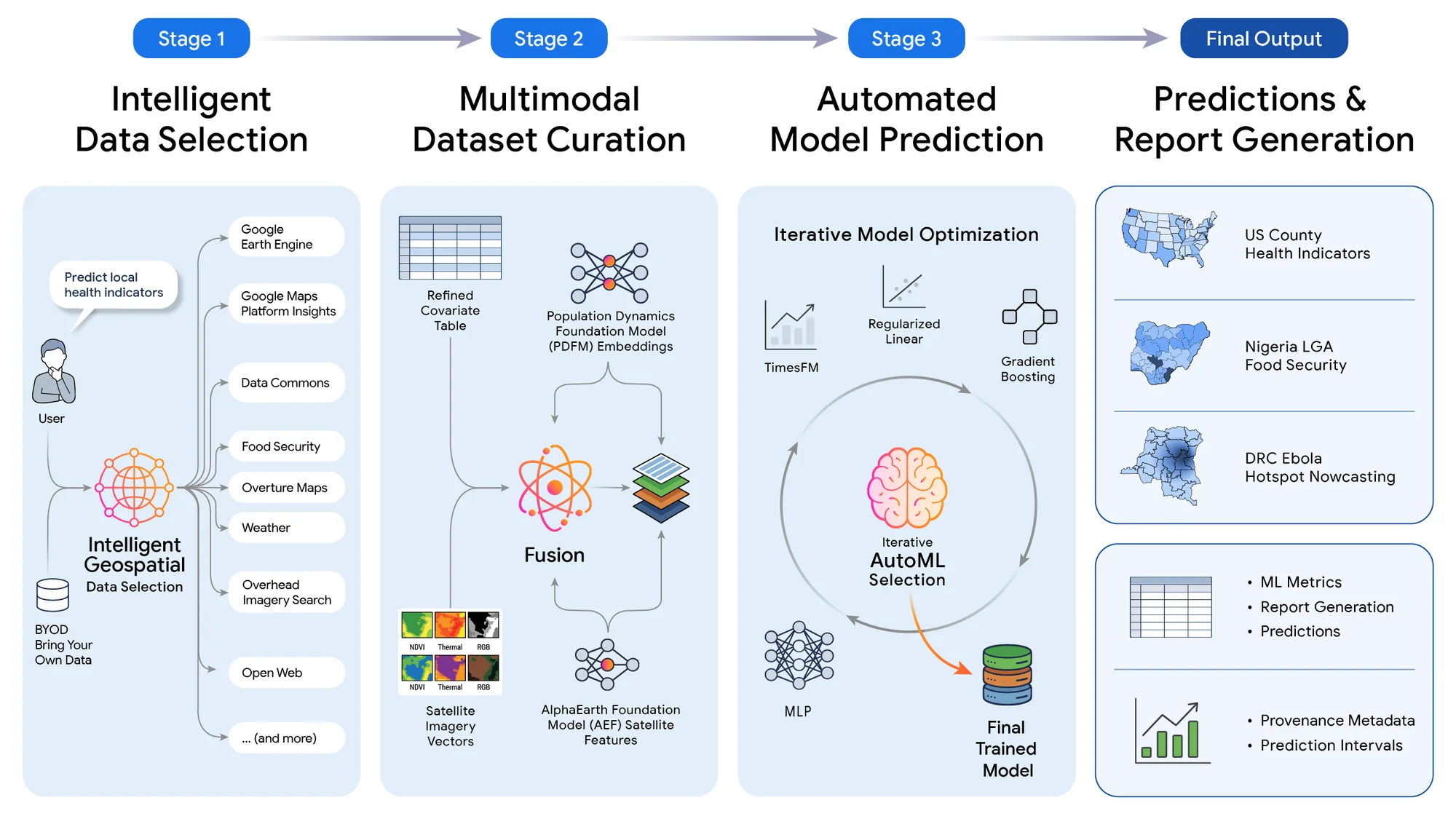
The PPE decomposes the predictive workflow into three modular stages, each orchestrated by an LLM:
Critically, each stage operates independently on well-defined inputs and outputs to prevent data bottlenecks. Data artifacts are passed between stages via opaque handles rather than serialized into LLM prompts, avoiding context-window limitations.
The PPE’s end-to-end workflow. The system decomposes the predictive workflow into three modular stages: (1) Intelligent data selection, (2) dataset curation, and (3) AutoML & prediction to produce the final predictions and report. Off-the-shelf LLMs serve as orchestrators within each stage.
We evaluated the PPE across a multidimensional matrix of machine learning paradigms, geographies, and scientific domains.
Across 21 CDC health indicators, the PPE’s intelligent data selection and multimodal fusion achieve a mean R² of 76.8% vs 60.0%, compared to a manual expert pipeline. We observe similar gains for predicting FEMA national risk indicators (mean R² of 64.9% vs. 60.0% baseline) and Social Vulnerability Index (mean R² of 66.2% vs. 58.6% baseline).
In data-scarce regions, coarse regional reporting often obscures local vulnerability. By autonomously integrating localized market shocks, food price anomalies, and microclimate indicators, PPE doubles baseline accuracy when downscaling food security from the provincial state (ADM1) level to the local government area (ADM2) level (R² 66.1% vs. 31.5%), providing humanitarian organizations with actionable, high-fidelity vulnerability maps.
Super-resolution food security downscaling in Nigeria (ADM1 State Level → ADM2 LGA Level).
For real-time prediction of new disease transmission hotspots during the 2026 Bundibugyo ebolavirus outbreak in the Democratic Republic of the Congo, the PPE achieves a Recall@10 of 83.3%, correctly identifying 15 of 18 newly invaded health zones across five sequential weekly forecasts. This represents a +10.3 percentage point absolute improvement over the published state-of-the-art Bayesian modeling baseline (~73%), driven by fusing epidemiological signals with PDFM embeddings and PPE-selected geospatial covariates.
A key finding across all experiments is the synergistic value of combining structured statistical covariates with latent foundation model embeddings. Neither modality alone captures the full picture: statistical covariates provide explicit, interpretable signals, while Population Dynamics Embeddings and AlphaEarth Foundations embeddings encode complex non-linear patterns learned from large pre-training datasets. Our ablation studies consistently show that multimodal fusion along with intelligent data selection outperforms baseline approaches, confirming that these representations are complementary rather than redundant. In future work, we want to expand these capabilities to include more geospatial data sources, and foundation model embeddings such as Remote Sensing Foundations multimodal embeddings.
Improvements from PPE’s multimodal fusion and intelligent data selection over baseline approaches.
The PPE demonstrates that autonomous AI systems can match or improve performance across a wide range of geospatial prediction tasks: from estimating chronic disease prevalence in the United States, to improving resolution of food insecurity in Nigeria and nowcasting active viral outbreaks in the Democratic Republic of the Congo. By combining intelligent data discovery, multimodal foundation model fusion, and automated model optimization, the PPE lowers the technical barrier to planetary-scale analytics, enabling rapid deployment when time-sensitive decisions are critical.
We believe this experimental research represents a meaningful step toward democratizing geospatial prediction. By shifting the focus from manual data engineering to high-level hypothesis direction, the planetary prediction engine helps researchers, humanitarian organizations, and policymakers build models without needing specialized engineering teams. While PPE is an early-stage research project, we’re excited to explore more use cases and see how this approach can help organizations better anticipate and solve complex global challenges.
We thank and acknowledge the contributions from all of the co-authors of the paper. We are grateful to the UN World Food Programme (WFP) and Vulnerability Analysis and Mapping (VAM) team for the data and research support. We also thank the Institut National de Recherche Biomédicale (INRB) for their collaboration on the DRC Ebola nowcasting, and the teams behind Data Commons, Google Earth Engine, Population Dynamics Foundation Models, and AlphaEarth for providing the foundational data and model infrastructure that power the PPE.
The source text above remains the property of its publisher and is reproduced for commentary.